Mountain hiking is a perfect option for adventure holidays as well as a day trip during our summer vacations, just to keep us fit and get away from crowded beaches and insufferable hot cities.
There are many benefits of mountain hiking, everyone knows that. The more physical effort, the better our state of mind and inner peace. And more interesting stories to talk about after we get back from our trips. 😉
So, Europe.
Europe is a paradise for every nature admirer. Home to the most beautiful mountains in the world.
There are countless trails: hut-to-hut routes, day hikes, via ferratas, some suitable for families with kids and the other appropriate only for experienced trekkers. So which one to choose?
The below list presents 20 best hikes in Europe recommended by fellow well-travelled bloggers and myself.
Table of contents
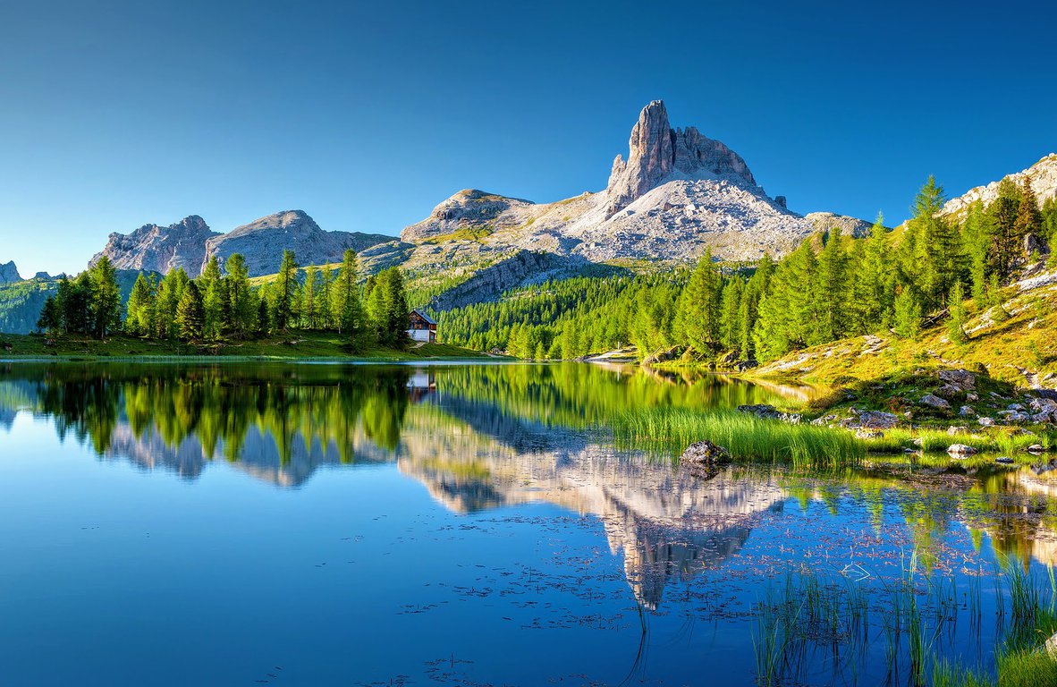
1. Alta Via dei Monzoni, Dolomites
Claudia - My Adventures Across The World
Length: 15km / 9.5mi
Time of hike (breaks included): 5 hours
Difficulty: medium
Alta Via dei Monzoni, in the Dolomites of Trentino, is one of the most beautiful hikes in Europe. It's a 15 to 20 km hike - the length really depends on the trail you decide to follow; and it can take between 5 and 7 hours, depending on how often you stop (and on which exact trail you pick).
The best starting point for hiking Alta Via dei Monzoni is the parking lot of Seggiovia Costabella in Passo San Pellegrino. From there, take the ski-lift to the beginning of the trail, which is at around 2000 meters above sea level, and start walking towards Rifugio Passo delle Selle, which is higher up at 2500 meters above sea level.
The best views of the hike are those of Cimon del Bocche massif, Lagorai, Latemar, Catinaccio and Pale di San Martino peaks.
Leaving Rifugio Passo delle Selle, the hike becomes a bit more difficult, following a very narrow trail that you should not follow if you are afraid of heights or get vertigo. If you continue walking, you'll go towards Austria's WWI trenches, where you can see various sniper points and artillery tunnels.
Past the trenches, you walk to Ponta de Recoleta, and then down to Fango. Alternatively, you can walk to Colifon, where the Italian trenches were located, and from there continue to the ski-lift that will take you to Passo San Pellegrino.
Alta Via dei Monzoni is not a strenuous hike, other than the parts where the trail is very narrow. The trail is well marked and easy to follow even without a guide, but I recommend hiring one that will be able to provide information about the history of the trenches and the surrounding landscape.
If you would like to stay in the beautiful region of San Pellegrino, you may find suitable accommodation here:
- Hotel Monzoni - 4-star accommodation located in Val di Fassa valley. It features a wellness centre and restaurant. Rooms are clean, spacious and cosy, the staff is friendly and attentive.
- Hotel Costabella San Pellegrino - 3-star charming hotel located right next to the Passo San Pellegrino slopes. It features a restaurant and a small wellness centre with sauna. Comfortable Alpine-style rooms with mountain view.
- Rododendro Apartment - brilliant location with a mountain view. The apartment features 2 bedrooms, an equipped kitchen with a microwave and a fridge, a washing machine and 1 bathroom.
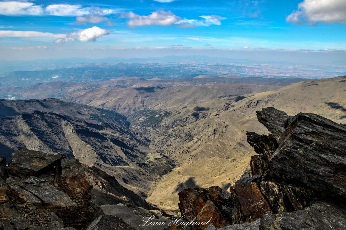
2. Mulhacen, Spain
Linn - Brainy Backpackers
Length: 10.5km / 6mi
Time of hike (breaks included): 6 hours
Difficulty: medium
If you want to try hiking in Europe, then Spain should be on your bucket list!
Mulhacen is the highest mountain in Spain (mainland, excluding Tenerife) - it reaches 3479 meters of altitude. The peak is a part of the Sierra Nevada National Park in the south of the country.
Mulhacen hike can be made in one or two days. The easiest way to get there is to go to the small village of Capileira. From there you can get a minibus up to Mirador de Trevelez which is at 2700 meters of altitude. It is not allowed to drive a private car to this point. You will need to book the minibus in advance both to secure a seat and to secure it is running.
It is only possible to do this hike in the summer and early autumn. You can easily get to Capileira from Granada by bus (2-2,5 hours) or car (1,5 hours).
You don’t need to be specifically fit to do the hike, though the altitude makes it hard to walk to last bit, that is also a bit rockier. The path is clearly marked most of the time. You are likely to spot wild mountain goats on the hike if you are lucky quite close up. The day hike takes about 6 hours from where the bus leaves you and back including lunch and snack breaks.
To complete safely Mulhacen hike you should prepare well for the mountain trip. Make sure to bring warm clothes and something to cover up head, neck, and hands as well as sunscreen and sunglasses. You never know if the weather changes, and even though it is in the middle of summer and the sun shines, you might be met with a strong, cold wind. Be prepared, and you will have a much more enjoyable day hiking. Also, it is important to bring enough water (minimum 2 litres per person) and enough food and snacks to keep your energy levels high.
If you want to stay close to Sierra Nevada mountains, check the below awesome places to stay:
- Melia Sierra Nevada - 4-star hotel located close to hiking trails and just 100 metres from Sierra Nevada Ski Resort. The hotel features a modern wellness centre, comfortable rooms with balconies, Tinaja de la Sierra restaurant, a buffet-style restaurant and tapas bar.
- Inside Plaza Sierra Nevada apartments - situated at the foot of Sierra Nevada ski resort. These are spacious and modern apartments which offer amazing views of the mountains. All apartments have a fully equipped kitchen.
- Hotel El Ciervo Sierra Nevada - budget accommodation. Amazingly friendly and helpful staff. Buffet breakfast is included in the accommodation price.
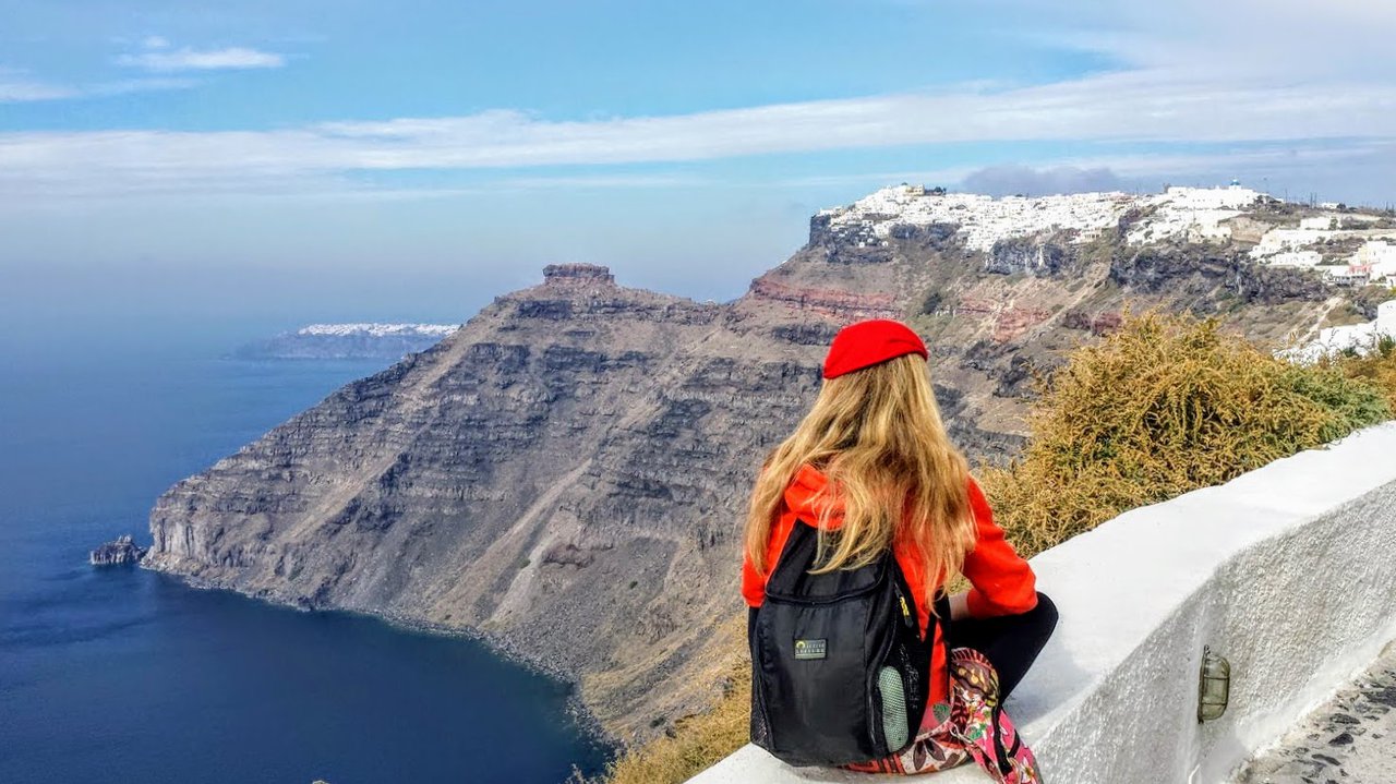
3. Fira to Oia, Santorini
Dave - Dave’s Travel Pages
Length: 10km / 6mi
Time of hike (breaks included): 4 hours
Difficulty: low
The hike from Fira to Oia in Santorini is one of the most rewarding activities you can do on the beautiful Greek island and one of the best day hikes in Europe!
The distance is about 10 km / 6.2 miles, and overall it’s an easy hike for anyone who is comfortable walking this distance, with very few uphills and downhills. The hike can be completed in a couple of hours, but in order to make the most of it and admire the views, allow about 4 hours or more.
The trail, which is generally very well marked, passes through some of the biggest villages in Santorini. Starting from Fira, the trail follows the coast passing through Firostefani and Imerovigli, and eventually reaches Oia.
You will see many landmarks and churches along the way, such as Skaros rock, the Monastery of Saint Nicolas, the Church of Agios Antonios, and the Church of Prophet Elias. Most importantly though, you will get to see the magnificent views over the Santorini caldera, a sight that you are likely to remember for a long time. In fact, the hike from Fira to Oia was our favourite experience on the island, and we totally recommend it.
To find the beginning of the trail in Fira, walk towards the cable car. You should be able to see the signs for the hiking trail, which begins in the square just next to Hotel Atlantis. If in doubt, just ask someone.
While in summer you should be able to find cafes and corner shops for snacks and drinks, if you go off-season it’s best to be prepared in advance. Whatever you do, don’t forget your sunscreen, sunglasses, hat, and comfortable walking shoes. If you hike in summer, try to avoid the hottest part of the day, which is around 11-4. You can either depart early in the morning, or leave early in the evening, and arrive in Oia for the famous sunset. Then you can get a bus or taxi to Fira.
Looking for more things to do in Santorini? Check out Dave’s Santorini Travel Guide.
If you'd like to stay in Fira, Santorini you can check the below options:
- Astro Palace Hotel Fira Santorini - a beautiful 5-star hotel located in the centre of Fira. Rooms are nicely decorated and have a large balcony or terrace overlooking the sea. Breakfast is abundant with lots of food options. The hotel features a SPA, gym and swimming pool.
- Anemomilos Suites - cosy apartments with balconies overlooking the Aegean Sea and Santorini area. The accommodation offers a swimming pool. Nice and clean, great value for money.
If you want to explore Oia village you may find great places to stay here:
- Canaves Oia Hotel - awesome 5-star hotel located on the cliff overlooking the Caldera and sea. First-rate facilities, attentive staff and a great variety of food served in a beautiful restaurant.
- Hotel Aethrio Oia Santorini - aparthotel built in Cycladic style and situated in the centre of Oia. Aethrio offers modern studios, apartments and spacious rooms. There is also a restaurant, swimming pool and rooftop terrace. Staff will go the extra mile to make your stay pleasurable.
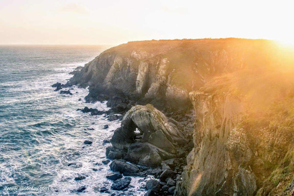
4. Pembrokeshire Coast Path, Wales
Length: 290km / 180 mi
Time of hike (breaks included): 2 weeks
Difficulty: high (if you want to complete the whole trail)
The Pembrokeshire Coastal Path offers spectacular scenery, historical sights, quaint seaside towns, and an abundance of wildlife. I consider this trail one of the best multi day hikes in Europe!
Running from St Dogmaels in the northern part of the Pembrokeshire Coast National Park, down to Armoth in the south, the coastal path covers about 180 miles and takes about 2 weeks to complete.
You can pick up the Pembrokeshire path by following the road from St Dogmaels, towards Poppit Sands, continue walking along the road past the YHA until you get to Allt y Coed Farm Campsite. This is where you’ll be able to come off the road, and onto the coastal hiking path. To get onto the path, go through the farm, then through a fence that is marked with an Acorn. If you’re in doubt of where to go during your hike, look out for the acorn sign that is used to mark the coastal path.
Due to a combination of varying terrain, the unpredictable weather and length of the hike, it can be quite strenuous. Some sections of the path, do not have any nearby facilities, so make sure you always take adequate food, drink and clothing. Most beaches along the coastal path are only accessible when the tide is out, so make sure to check tidal times before heading off.
The most challenging section, is St Dogmaels to Newport, covering about 15.5 miles of steep hills, uneven paths, which can become slippery when wet. Plus there’s a lack of easy to access facilities along this path so make sure you are properly prepared. If you’re new to hiking, I recommend skipping this section but despite its difficulty in places, the coastal path is definitely worth hiking.
If you only have time to hike part of the Pembrokeshire Coast Path, I highly recommend hiking the St David’s Head to Nolton Haven path, which takes 1 day to complete. This will give you a good taste of what Pembrokeshire has to offer, covering historical sites such as St Non’s Nunnery (the birthplace of St David), rugged terrain with spectacular views of the sea, and some beautiful beaches.
Here are a few fantastic hotels near Pembrokeshire Coast National Park:
- Llety Farm - B&B located in St David's, Haverfordwest. Beautiful accommodation offering amazing mountain view. Hosts are very friendly and helpful.
- The Grove Narberth - luxurious 18th-century hotel situated in Narberth, in quiet countryside close to hiking trails. Rooms are spacious and beautifully decorated. The hotel features a restaurant.
- Victoria Inn Brewhouse Roch - cosy B&B located just 15 minutes on foot from famous Roch castle. Rooms are nice and clean, some overlook the sea. Wide variety of food available in the morning.
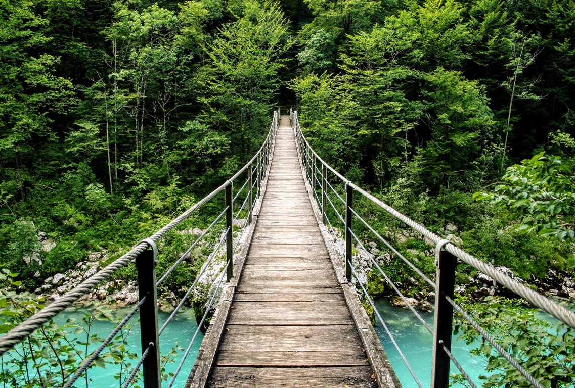
5. Soca trail, Slovenia
Leo - Safari Nomad
Length: 25 km / 16mi
Time of hike (breaks included): 8 hours
Difficulty: medium
The Soča hiking trail, a beautiful part of Alpe Adria trail in Triglav National Park, runs along Soča river from its spring towards the town of Bovec.
The walk, which measures 25 km in length, is a medium difficulty trail to follow and suitable for children and elderly people as long as they are in a good physical condition (it can be tiring). The trail is marked with information boards set up at several information points along the trail.
This hiking trail not only boasts many beautiful views, but it offers also many sights, such as the Mlinarica gorge, Alpinum Juliana Botanical garden, Trenta lodge, small Soča gorge, gorge at Kršovec and suspension footbridges along the way. Triglav National Park is truly one of the best places to hike in Europe.
Estimated time of the walk is 7-8 hours but if you take time to look the sights along the trail, it might take you longer. If you are not ready to walk so many hours, don’t stress out. The length and direction of the road can be tailored to your available time and capability.
To reach the trail, turn off the Trenta-Vršič road and drive until you get to the car parking in front of the Triglav National Park Information Centre. You can also take a bus (in summer months only) but in this case, you will need to walk about 30 minutes till the source of Soča river.
The best time to hike Soča trail is summertime. Use comfortable hiking shoes, protection against wind and rain, a bottle of water and something to eat.
If you want to explore other natural wonders in Slovenia you can also visit nearby Vintgar Gorge.
To stay close to hiking trails it's best to choose Bovec - picturesque mountain town perfect to explore Triglav National Park. Here are a few interesting places to stay:
- Hotel Dobra Vila Bovec - situated 200 metres from Bovec centre, this fantastic hotel is housed in a historic telephone central office. Rooms are nicely decorated and comfortable. The hotel restaurant offers fantastic food.
- Hotel Mangart Bovec - great location very close to hiking trails. Comfortable rooms with a mountain view. Tasty breakfasts with a lot of food choices.
- Krona Apartments - spacious apartments with fully equipped kitchen, everything is nice and clean. Friendly and helpful host.
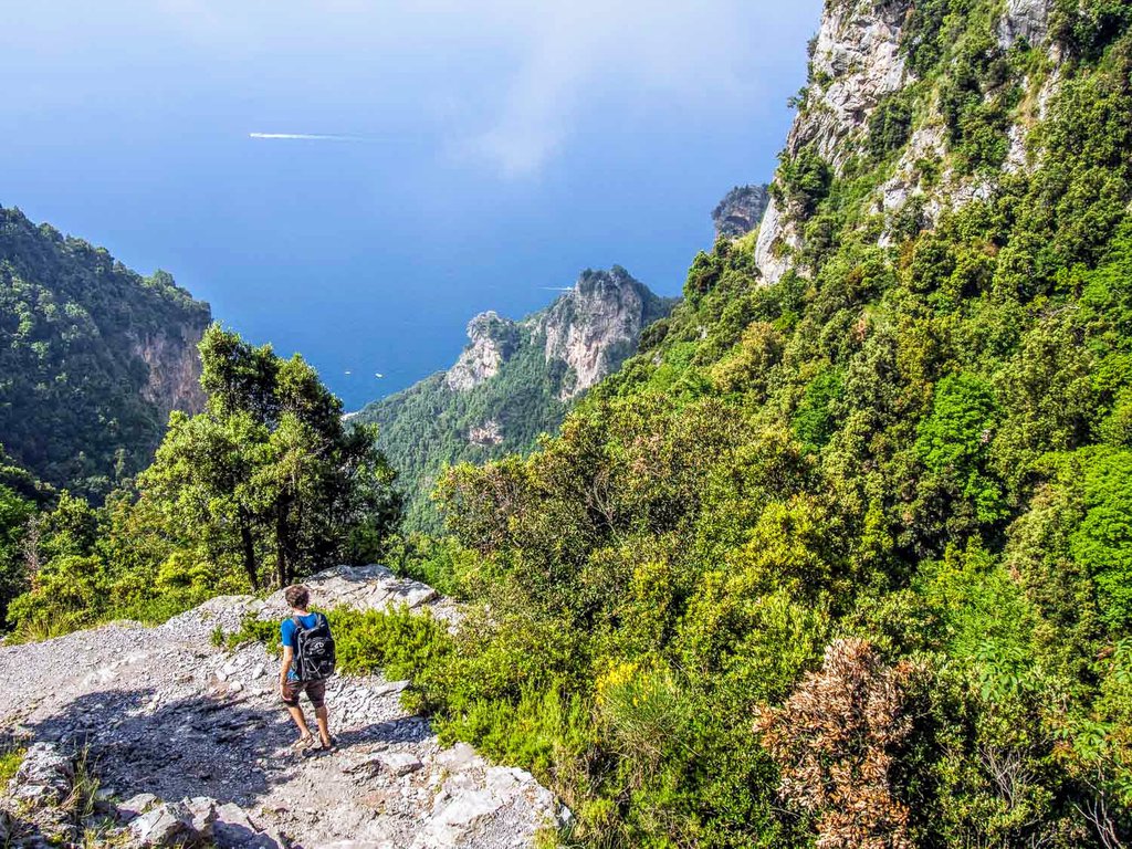
6. Path of the Gods, Italy
Erin - Never Ending Voyage
Length: 6.5km / 4mi
Time of hike (breaks included): 2 hours
Difficulty: low
Path of the Gods (or Sentiero degli Dei in Italian) is a stunning hike on the Amalfi Coast in Italy. I consider it one of the most beautiful easy hiking trails in Europe.
The trail is carved into the cliffs high above the sea and there are gorgeous sea views along the way. You’ll also get excellent views of limestone mountains and beautiful coastal towns like Positano. You’ll walk past meadows of wildflowers and long grasses, ancient abandoned stone houses, and vineyards on terraces carved into the hillside. Donkeys are still used to transport grapes along the narrow paths.
The main section of the hike is 6.5 km (4 miles) between the small villages of Bomerano and Nocelle. It took us under two hours, and we enjoyed it so much that we turned around and walked back rather than continue down to Positano (as most people do) and take the bus back from there.
The trail is a mix of ups and downs and isn’t too difficult if you are reasonably fit. It is rocky and uneven so good shoes are important (hiking sandals were fine for us).
You can also connect to the trail from the coastal towns of Praiano (below Bomerano) or Positano (below Nocelle), but you’ll have to walk up (or down) over 1500 steps and it makes the hike much more strenuous.
We chose to stay in the quiet village of Furore instead. It’s a 20-minute bus ride (or 50-minute walk) from the start of the trail in Bomerano and is amazingly beautiful offering landscape of dramatic cliffs descending into the azure sea. Bomerano village is another convenient place to stay for the hike.
The Path of the Gods is popular so I highly recommend getting an early start. We left Bomerano at 7.30 AM in June and had the path to ourselves until near Nocelle. It’s also cooler in the morning. The route is easy to follow - just look out for the red and white markers.
I highly recommend this hike for an alternative perspective on this beautiful coast. See our Path of the Gods guide for more tips.
If you would like to stay in Furore, you can check the below accommodations:
- Hotel La Locanda Del Fiordo Furore - located on the cliff with direct access to the sea. Each room has a private terrace and a view over the ocean. Hotel's restaurant serves delicious Italian food also with vegetarian and gluten-free options.
- Holidays Fico D'India - beautiful accommodation perfect for nature lovers. Comfortable rooms overlook the sea. Excellent food.
- Residence Calipso - cosy and comfortable apartments with a fully equipped kitchen. Each apartment overlooks the sea. The owners are exceptionally kind and helpful.
7. Ben Lomond, Scotland
Clare - Travels In Peru
Length: 11km / 6mi
Time of hike (breaks included): 6 hours
Difficulty: low
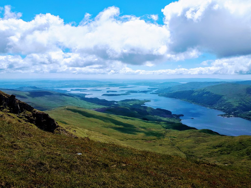
Ben Lomond is located on the shores of Loch Lomond lake in the highlands of Scotland. It is 974 metres above sea level, with amazing views on clear days and is certainly one of the best hikes in Scotland.
The easiest way to get to Ben Lomond is by car, it is around 1 hour 15 minutes drive north of Glasgow to Rowardennan where the trail starts in the car park. It is also accessible by public transport, you can either get a bus or train from Glasgow to Tarbet and then cross the Loch by water ferry.
I personally decided to stay in Balmaha - a nice and quiet village located 20-minute drive from Ben Lomond car park in Rowardennan.
There are 2 options for the hike, the easiest is to start the hike from the car park as this is quite a gradual incline to the summit. This option is tough for people not used to hiking but for experienced hikers an enjoyable hike.
The other option that I did was to take the path just past the Ben Lomond Bunkhouse. This is a harder and steeper route with a little bit of climbing needed towards the top.
The hike itself takes between 5-6 hours return trip, though it can take longer if you are stopping to take pictures and want to rest. On a beautiful day like I had, it was hot hiking up and I started off in just a t-shirt, the higher up you get, the wind becomes stronger and you do need to make sure you have sufficient layers and waterproofs with you as the weather in Scotland can change very quickly.
Make sure you do stop on the way up and down though to appreciate the amazing views. The views looking down at the Loch Lomond and the surrounding mountains was amazing and the highlight of my trip to Scotland.
Hiking in Europe is not only about the Alps - Scotland has amazing mountains too!
If you wish to stay close to the picturesque region of Loch Lomond And The Trossachs National Park you may check the below interesting places to stay:
- Oak Tree Inn - located in nice and quiet area in Balmaha village. Spacious and beautifully decorated rooms. Delicious and ample breakfasts.
- Loch Lomond Waterfront Lodges - luxurious lodges with a private beach. Each facility features a fully equipped kitchen and an en-suite bathroom. Private hot tubs can be hired.
- Birchwood Guest Lodge - lovely wooden guest house. The owner is friendly and very helpful. Great value for money.
8. Folgefonna, Norway
Kenny - Knycx Journeying
Time of hike (breaks included): 6-7 hours
Difficulty: medium
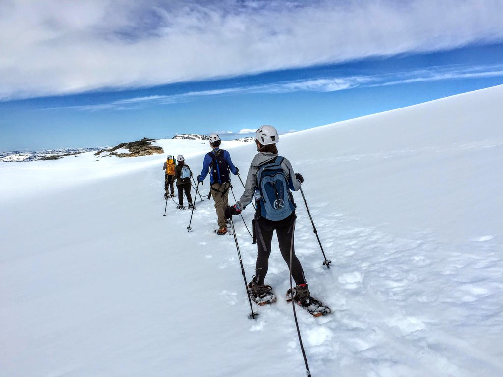
Folgefonna is part of the Folgefonna National Park and the third largest glacier in Norway. While the glacier is closed in winter, it is great to explore in summer – and that’s what we did when we were in Bergen.
We headed to Folgefonna in the morning for a full day glacier hiking tour.
Getting from Bergen to Folgefonna National Park takes about 3 hours. First, take a bus to Norheimsund, and then take a speedboat to Herand, and finally, the Fonna Glacier Ski Resort is another bus ride away (Fonna is a summer ski centre on Folgefonna glacier).
After checking in and a short briefing, we were given a helmet, poles, and snowshoes. We were first all connected with a rope and later the group was separated to walk up or walk around. It is more difficult and challenging to walk up, and easier and more relaxed to walk around and enjoy the view.
A glacier is a slowly moving river of ice. The ice accumulated at the top of the mountain over the long, cold winter would exert pressure to the bottom and cause the glacier to move. These glacier movements crafted and shaped the dramatic landscape of the fjords and valleys in Norway, and the breathtaking view of always make me feel humble. I consider Folgefonna National Park as one of the best places to hike in Europe!
All in all, the hike took about 7 hours and it was not very difficult and very safe. However, it does require more energy to walk on ice with snowshoes. It's worth to learn about winter hiking before the trip.
Bring your own lunch and enjoy the food at the top of the glacier with an amazing view. Although you will be surrounded with ice, it was actually not that cold and you might even feel hot as you are walking up the glacier, so dress in layers. Lastly, don’t forget your sunglasses, sunscreen, and your camera to take a lot of pictures!
If you would like to stay near Folgefonna National Park you might want to check below options:
- Rosendal Fjordhotel - excellent location - the hotel is in a picturesque village of Rosendal, close to Hardanger Fjord. Fabulous views from the hotel. Staff is friendly and attentive. Food is delicious, a wide variety of choices available.
- Hardanger Hotel - located in the town of Odda. Comfortable and spacious rooms overlooking Sørfjord. The hotel is a great starting point for hiking trips.
- Akrafjorden Nature B&B - located in a quiet village of Fjæra, close to a lake, waterfall and hiking trails. Perfect for nature lovers and peace seekers. Nice and cosy rooms.
9. Pico Ruivo, Madeira
Liona - Travels With Ted
Length: 14km / 8mi
Time of hike (breaks included): 5-6 hours
Difficulty: high
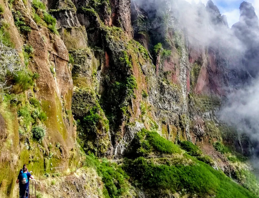
I didn’t plan on doing much hiking when I first arrived in Madeira. With two small children, I don’t get much chance to anymore. But when the opportunity to walk the trail from the third highest peak on the island to the highest I borrowed some hiking shoes and nervously took my place at the start.
The start is found at Pico do Arieiro, Madeira’s third highest peak. It can be reached by a spectacular drive above Funchal, the island’s capital. There is a large car park, cafe and gift shop which looks down on the clouds on all but the clearest days. The peak itself is just a few metres from the car park.
The first section of the hike receives the most attention from tourists due to its accessibility and incredible views. The price paid for those views is vertigo-inducing land bridges with drops on either side.
Your destination is Pico Ruivo - the highest mountain in Madeira. At 1,862m it's not only the highest point in Madeira but also the third highest peak in Portugal.
The peak can only be reached on foot via a number of trails of varying difficulty. The hike from Pico do Arieiro is the most popular and deservedly so. Cloud cover often means the views will be obscured but those brief moments when the beauty of the island reveals itself are unbelievable.
Pico do Arieiro to Pico Ruivo hike is a bit difficult but well-liked route. The route is a 14km round trip and usually takes 5 to 6 hours to complete.
It is tough at times with extremely steep sections and long accents. The path leads you up ladders, through tunnels and along ledges with sheer drops. Fortunately, the track is well-maintained and sign-posted. Be sure to take note of safety advice as sometimes the path is closed due to landslides.
This is the most difficult hike I have attempted in several years and at times I wasn’t sure I would make it to Pico Ruivo. It was absolutely worth the struggle and I would whole-heartedly recommend this hike to anyone visiting Madeira.
10. Kungsleden, Sweden
Aaron Teoh
Length: 110km / 68mi
Time of hike (breaks included): 7 days
Difficulty: medium
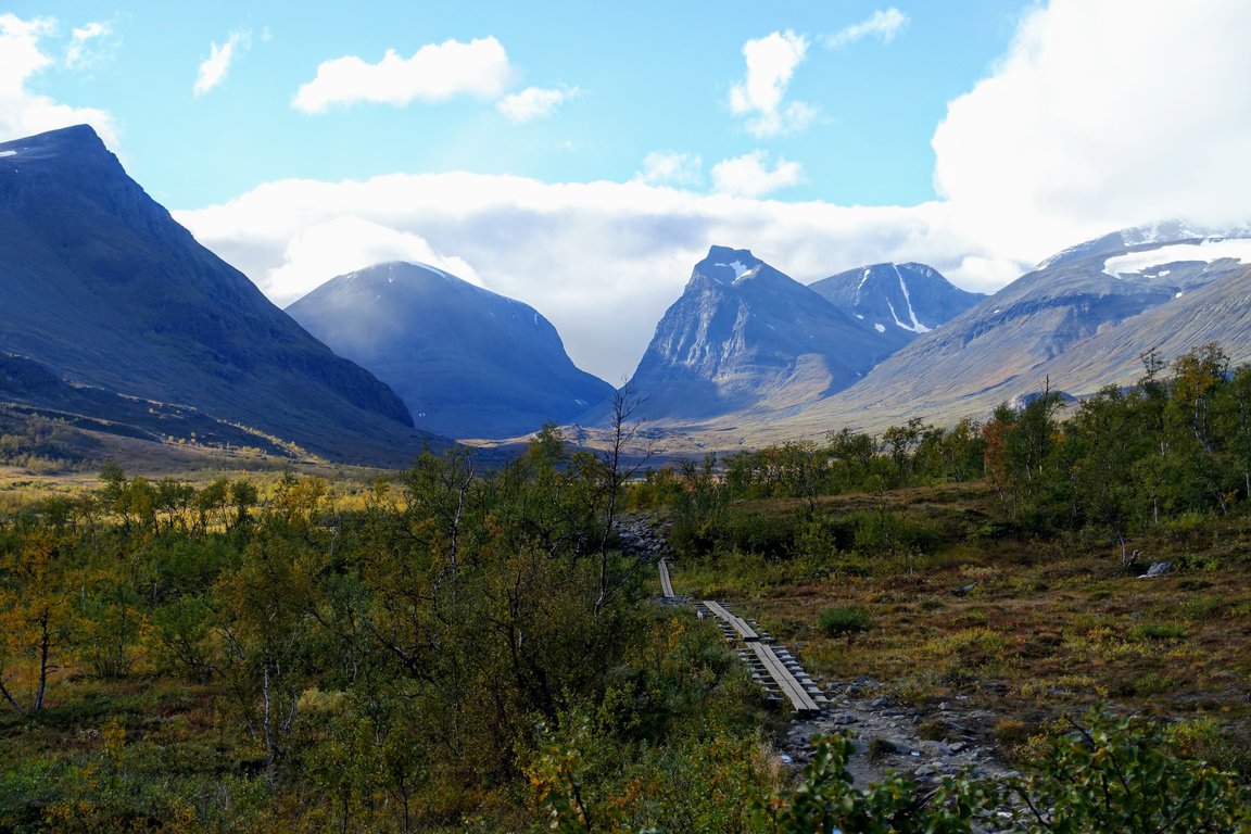
On this trail, you’ll get to experience the magnificent subarctic landscape, walk through vast glacier-carved valleys flanked by snow-capped peaks, and end each day in a warm, comfortable cabin. I think it's one of the best long distance hiking trails in Europe.
The nearest city to Abisko and Nikkaluokta is Kiruna. There are multiple flight and train connections between Stockholm and Kiruna daily. From Kiruna the train continues to Abisko (and onward to Narvik in Norway). There are also a few buses a day between Kiruna and Nikkaluokta.
The section between Abisko and Nikkaluokta can be completed comfortably in 7 days, doing one hut’s distance each day, or in as short as 3 days for trail runners with a small pack.
This is probably one of the easiest hut to hut hikes in Europe as there are not many steep climbs and descents, and only one short mountain pass to cross. Furthermore, the cabins, complete with beds and gas stoves, make it possible to travel with a lighter pack. As such, the trail is one of the more manageable ones around, though good preparation is still essential. I consider Kungsleden trail one of the best multi day hikes in Europe.
If you decide to take along a tent, you can camp almost anywhere along the trail, in accordance with Sweden’s right to access law. Allow more time to enjoy the Kungsleden, as there are a couple of possible side trips along the way, such as climbing Sweden’s tallest mountain, Kebnekaise, or staying a night in a cabin surrounded by glaciers, at Tarfala Valley.
11. Krnsko Jezero, Slovenia
Pashmina - The Gone Goat
Length: 14km / 8mi
Time of hike (breaks included): 4 hours
Difficulty: low
When you think of the most stunning hikes in Europe, most people would head to the Dolomites in Italy or the Austrian Alps - rarely do people consider Slovenia, a hiking paradise.
It has the greenest lakes, known as the most forested country in Europe, the top greenest country in the world with increased efforts to make Slovenia a place for community-based tourism and responsible tourism.
While spending my summer in Slovenia, I hiked one of the best easy hiking trails in Europe - Krnsko Jezero in Bovec.
The lake is surrounded by colourful poppies, including several endangered species such as the yellow Kerner Alpine poppy. The 2-3 hour hike to Krnsko Jezero lake (1350m) in the Lepena Valley brings you to an open mountain on the green trails where you will see a beautiful emerald-green lake. We sat there in the open and gazed at the breezy grasslands overlooking the lake, and seeing baby frogs hop from one rock to another. I consider this trail as one of the best day hikes in Slovenia.
Swimming in this lake is not an option due to the preservation of the ecosystem, which is already very endangered due to artificially inhabited fish.
There’s no direct bus that goes to Lepena Valley. The best way is to take the bus from Bovec that goes to Kranjska Gora and ask if they go to Lepena Valley. Alternatively, ask the tourism office for the best route to go here and see if you could hitchhike halfway. The trail is well-marked and it will take you approximately 4 hours to complete it.
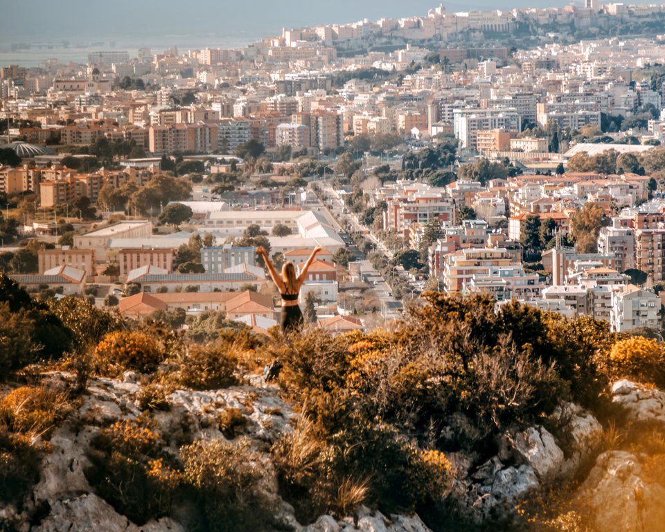
12. Sella del Diavolo, Italy
Hanna - Solar Powered Blonde
Length: 4km / 2.5mi
Time of hike (breaks included): 1 hour
Difficulty: low
Sella Del Diavolo, which means Devil’s Saddle, is a stunning hike near Cagliari, Sardinia. Once you reach the top the views are over the bright blue sea on one side, and the city below on the other side.
We actually stumbled upon this hike, as we were trying to walk up to an old bunker to see it up close and didn't realise it was a hike to get to it. Sardinia is full of Pill Boxes, some on beaches but mainly up on top of hills and mountains by the sea.
The Sella Del Diavolo hike starts at the car park near Calamosca beach. However, as it is a military area with lots of barbed wire, the path starts a little further up the road.
It takes about 40 minutes to complete and is a very easy hike, perfect for families with kids. However, it does get warm as it isn’t shaded at all. You need good shoes though, as the path is very rocky at times and there isn’t a clear cut path.
I can definitely say it is well worth the sweaty hike when you get to the top - it's one of the best hikes in Sardinia. There are many viewpoints along the way over both the sea and Cagliari, but the best viewpoint with the clearest and bluest water is once you reach the top. Here, there is an old military bunker. It doesn’t have an entrance as such, but we climbed up over the top and the view gets even better. There is also a spot for a picnic at the top with some tables, and once you hike down you can head straight to the beach at Calamosca.
We hiked this trail in March and it wasn’t busy at all. Because of the fact the trail isn't shaded and it's best not to hike it in the summer. I consider Sella Del Diavolo one of the best winter hikes in Europe.
13. Carrauntoohil, Ireland
Chrisostomos - Trip And Trail
Length: 12km / 8mi
Time of hike (breaks included): 5-6 hours
Difficulty: medium
Ireland is not famous for its high mountains and indeed the highest mountain in Ireland - Carrauntoohil, is just 1038m high, but that doesn’t make climbing it a lesser experience. On the contrary, the fact that any person with average fitness can summit it and consequently climb on the top of Ireland makes it a great opportunity.
Carrauntoohil is near the city of Killarney in County Kerry and belongs to the Macgillycuddy Reeks mountain range. The nearest international airport is Cork and there are plenty of options to stay near Cronin’s Yard which is the most common starting point for climbing Carrauntoohil.
If you pick the easiest route which is through Devil’s Ladder, the 12km long (with 900m elevation gain) hike will take you between 4 and 6 hours to complete. Not very difficult but not a walk in the park either. The whole route is very scenic and even if the top has no visibility—which is pretty common, the views of the mountain and the loughs Gouragh and Callee, will more than reward you. Many hikers consider Carrauntoohil the most picturesque and easy hiking trails in Europe.
There are no technical parts and therefore no need for special equipment. A very crucial parameter is the weather. Going for it under the rain is a bad idea and I would strongly advise against it. The Devil’s Ladder is basically a 300m high gulley and there will be water coming down, making it slippery and potentially dangerous. High-velocity winds are one more thing to look out for.
The best period to climb Carrauntoohil is between April and September or even later in Autumn, weather permitting.
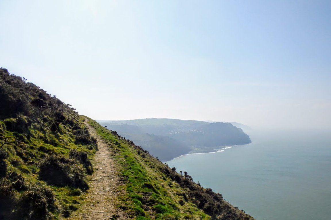
14. South West Coast Path, UK
Danny - What's Danny Doing
Length: 1014km / 630mi
Time of hike (breaks included): 30 days
Difficulty: high
South West Coast Path, beautiful and well-known, is one of the best hikes in UK. Many hikers even consider it one of the best multi day hikes in Europe!
It’s a long one! The hike takes you 630 miles around the south-west coast of England, through some of the most beautiful and picturesque parts of the country.
People tackle SWCP in different ways. For some brave souls they walk the entire length of the track in one go. From start to finish they go with no stops. However, the majority of hikers walk it in sections over time. They come and go, walking a few miles here and a few miles there.
However you decide to do the route, you’ll wander the length of Minehead, in Somerset, to Poole in Dorset. This mammoth walk takes your around tiny historical seaside villages, through larger touristy towns and along coastal trails that will take your breath away (in more ways than one).
I’ve only done sections of the hike, but I know people well on their way to completing it. The hike varies in difficulty. From long flat stretches to extended periods of serious ups and downs. Indeed, finish the walk and you’ll have climbed over 114,000 feet in total (that’s four times the height of Everest!). Not bad going for a coastal walk, eh?!
Spring and summer are the most popular times to walk the SWCP. It’s drier, sunnier and generally offers better weather than the cooler months. However, people do walk it all year round. It’s simply a matter of preference and having the right gear! Enjoy!15. Luminy to Cassis, France
Elisa - France Bucket List
Length: 20km / 13mi
Time of hike (breaks included): 6 hours
Difficulty: medium
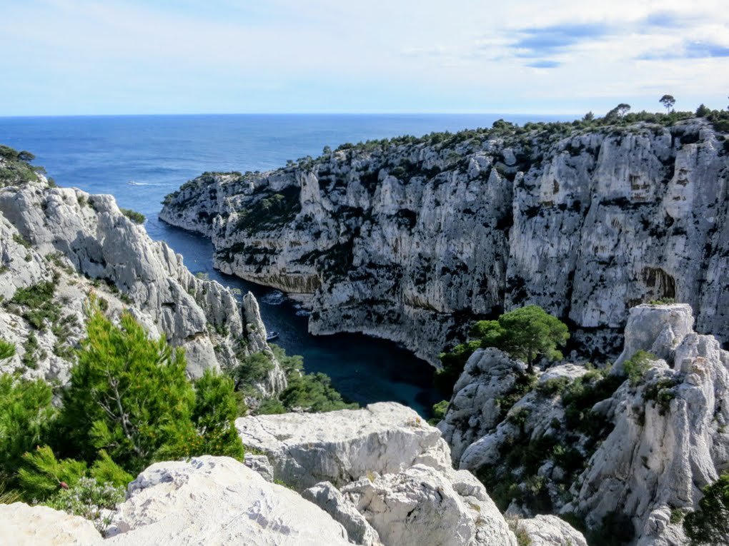
Le Parc National des Calanques Marseille - Cassis is a coastal park located in the South of France, between Marseille and the cute village of Cassis.
This Mediterranean National Park includes a terrestrial part, made of limestone cliffs and pudding, many creeks and islets and the marine part. This is a great park for hiking because it combines mountains and sea, with the option to stop for a refreshing bath when the weather is too hot.
Calanques National Park offers some of the best hikes in Europe - there are many beautiful and well-marked paths, most of them parallel to the sea. Some of the starting/finishing points can be reached by public bus and alternatively you can take a taxi.
We took the hiking trail from Luminy to Cassis, following the Devenson cliffs. This is a 20 km hike with three points a little bit complicated and with more than 1000m of height difference. During the hike, we had the option to walk down to two creeks - Calanque de Sugiton and Calanque de Port-Pin - and have a bath in its secluded beaches only reachable from the sea by catamaran.
The hike ends at the beautiful village of Cassis, where it is a good idea to sit and relax in the harbor with your favorite drink before taking the bus back to Marseille.
Hiking trails in Calanques National Park are located rather low above sea level - the highest point is Mont Puget at 565 metres. But still, hikers who want to explore Calanques need to be fit because paths go up and down all the time.
Hiking in Calanques National Park gets more difficult during the summer when hikers usually walk under the blazing sun of Provence so we recommend the shoulder season for hiking Calanques. Strong winds (Mistral) are also common in this area from Marseille to Cassis.
16. Furnas Valley, Azores, Portugal
Michele - A Taste for Travel
Length: 9.5km / 6mi
Time of hike (breaks included): 3 hours
Difficulty: low
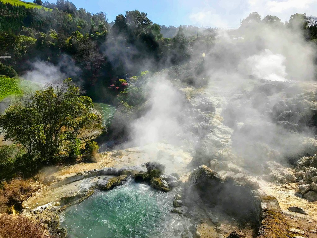
If you're looking for unique and fascinating outdoor adventures in Europe, then you don't want to miss a hike through the Furnas Valley on the island of São Miguel in the Azores, Portugal.
One of the top things to do in the Azores is to explore its landscape filled with dry calderas, craters lakes, fumaroles and thermal waters created by its still-active volcanoes. The Furnas Valley is home to a hike where you can experience it all - a jade green crater lake, geothermal springs and fumarolic fields with openings in the ground where hot, sulphurous steam escapes.
Although the Furnas Valley and the municipality of Povoação are just a short 30 drive away from Ponta Delgada, the capital of São Miguel, it's a world away in atmosphere. The experience begins as you drive to the town of Furnas along winding roads flanked by hedges of hydrangea. When you arrive in the heart of town, you'll be greeted by the amazing sight of hot steam rising from openings in the ground. The smell of sulphur is strong but be sure to stop and sip some of the mineral-rich volcanic waters from the public drinking fountains before beginning the 3-hour hike.
The 9.5-kilometre hiking trail is a loop that begins and ends in the town of Furnas and at points shares a path beside a narrow road with cars, but is still relatively quiet and peaceful. It's incredibly scenic as you rise in elevation to Lagoa das Furnas, a volcanic lake, where the views are incredible.
Follow the hiking path back to the town of Furnas where you can relax at Terra Nostra Park, where a swimming pool of iron-rich hot springs is set among a forest of 2,000 trees. Soak away any aches and pains in the soothing thermal waters.
The town of Furnas also happens to be one of the best places to enjoy cozido, traditional meat and root vegetable dish cooked by volcanic heat in underground pits.
The Azores are one of the most unique places in Europe and a great idea if you want to experience some unforgettable outdoor adventures.
17. Ordesa Valley, Spain
Dave - Jones Around The World
Length: 16km / 9.5mi
Time of hike (breaks included): 3 hours
Difficulty: low
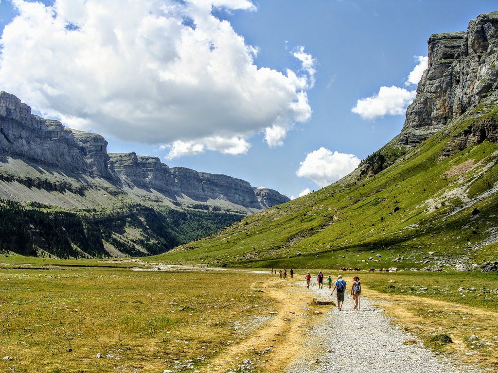
I recently just finished a two-week road-trip through the Pyrenees in Northern Spain, and I honestly can't believe it took me so long to visit this stunning region of my favourite country in the world!
The mountainous landscape will truly have you in awe, especially if you make it to the small town of Bielsa, and spend a few days exploring the hiking trails!
While there are several different hikes to choose from in Ordesa National Park (all varying in distance and difficulty), my personal favourite is the Ordesa Valley Hike! This trail takes you through a beautiful National Park and ends in the stunning Ordesa Valley, which will make you feel like you're on the set of Lord of the Rings, because you're surrounded by tall mountain peaks, that have countless waterfalls running down the sides (well, depending on the time of the year)! Ordesa National Park is truly one of the best places to hike in Europe.
What I really loved about this hike was that you actually had several different options on how to get there, and it really just depends on how steep you want to climb. I think a fun way to do it to take the slow way up that goes all around the mountain, and then take the fast way down (but it can be pretty hard on the knees). Another great option is also a walk along the valley floor which is a 16-kilometre long hike and takes about 6 hours to complete. It's technically easy and one of the best day hikes in Europe!
My top recommendation would be to stay at the Parador de Bielsa because it's located right at the base of the hiking trail, and is one of the cutest hotels I stayed at during my time there!
While this hike was that difficult at all, it was definitely my favourite thing we did during the entire Pyrenees road trip! Just make sure you plan ahead for the weather, and follow all the safety signs (and don't risk hiking during rainy days)!
18. Velika Planina, Slovenia
Lori - Travlinmad
Length: 15km / 9.5mi
Time of hike (breaks included): 5 hours
Difficulty: low
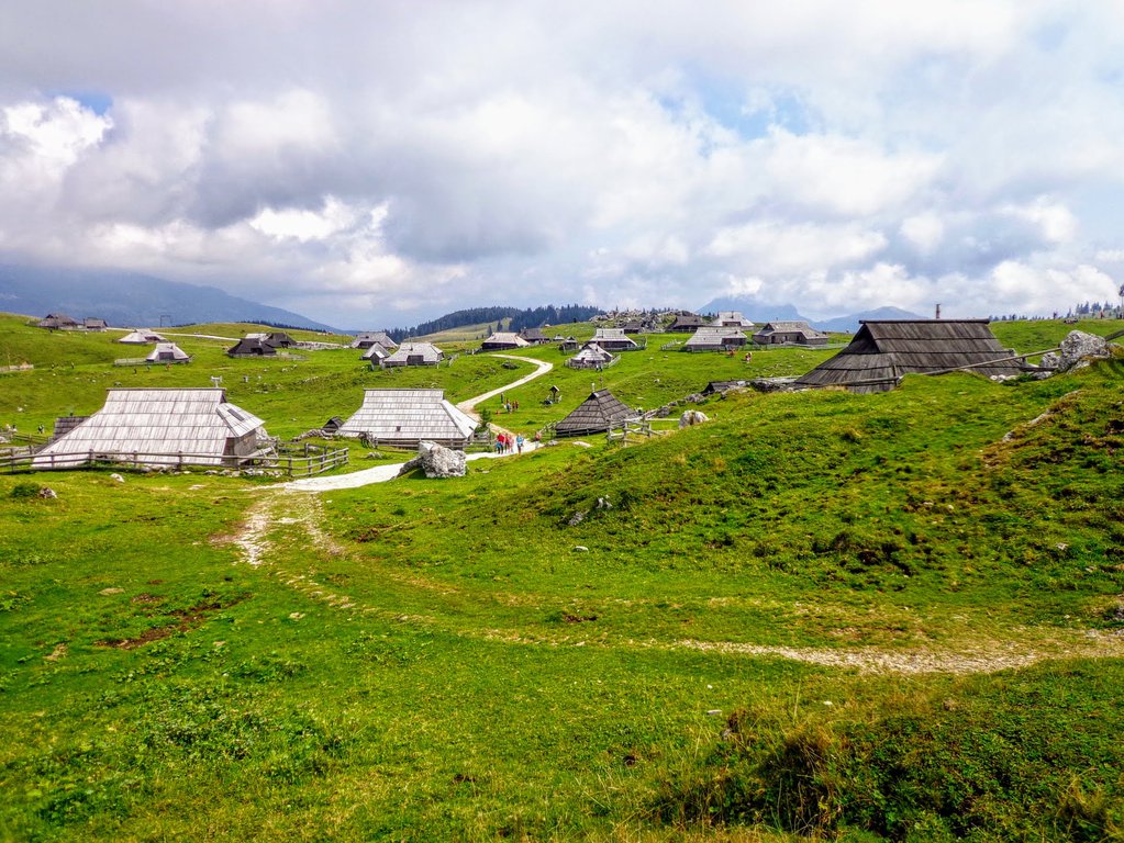
If you love lush green landscapes and alpine vistas, you’ll love Slovenia. But even several weeks of exploring the small country couldn’t prepare us for the incredible hike to Velika Planina in northern Slovenia not far from Ljubljana.
A day hike to Velika Planina, the high mountain plateau pasture and traditional herdsmen settlement outside Kamnik, offers hikers breathtaking views and one of the most unique hiking experiences in Slovenia.
This mountaintop area is part of the Kamnik-Savinja Alps and the views from 5,000 feet are magnificent (the highest point reaches 1611 metres).
You can hike from the parking area in the valley of Kamniška Bistrica all the way up to the top, or hop on the cabled gondola that takes you up the steep mountainside to a traditional ski chair lift for the last 300 feet to the top.
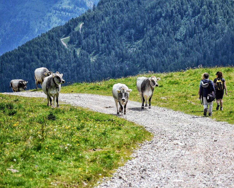
The herdsmen settlement is popular during the warm summer months between June and September when the herdsmen bring their cows to the mountain top to graze. Their huts are historic in design and many now have modern conveniences and can be rented during the off-season. It’s truly one of the most interesting cultural attractions in Slovenia.
You can hike to their settlement and visit a small museum, the hilltop chapel and even enjoy some homemade cheese with the herdsmen themselves. Or explore the trail system that winds along the ridgeline to several other small towns nearby.
You won’t see many other hikers on the plateau but the quiet will be interrupted now and then with the tinkling sound of cowbells as you pass by herds of cows grazing on the flowers and grass that cover the pastures. Velika Planina is truly one of the best places to hike in Europe!
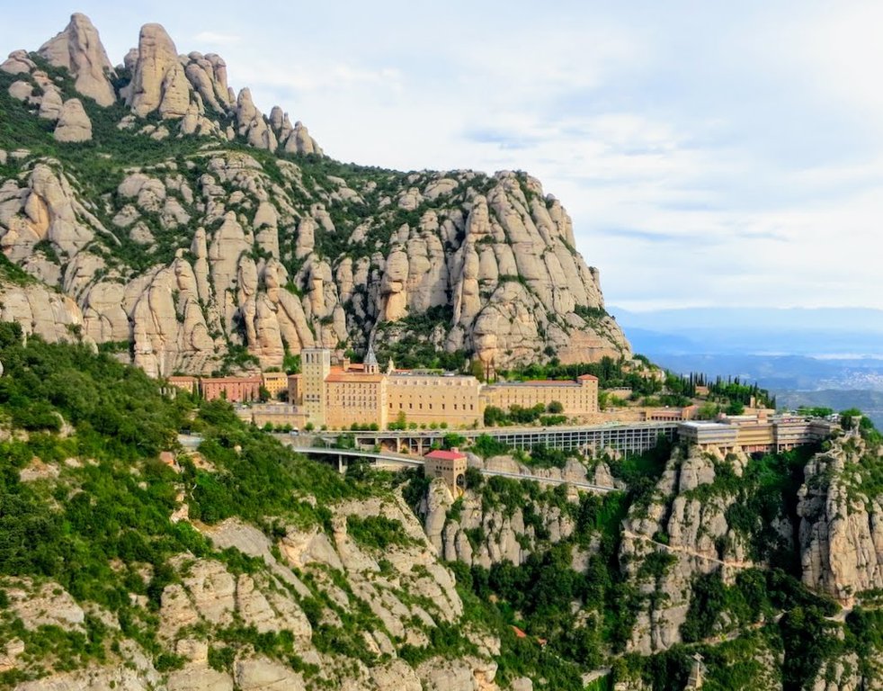
19. Montserrat, Spain
Carol - Wandering Carol
Length: 7km / 4.5mi (without the funicular ride)
Time of hike (breaks included): 3.5 hours
Difficulty: low
Montserrat Mountain in Spain, 31 miles northwest of Barcelona, is one of the most iconic hiking areas in the country. The Sierra de Montserrat, which translates as the Serrated Mountain, is a dramatic rise of sedimentary rock known as a pink conglomerate and is a striking mix of softly-rounded rock formations, cliffs and peaks.
Adding to the experience is the sacred nature of the mountain. A historic Benedictine monastery, the Santa Maria de Montserrat, is located here and is a good starting point for your hikes.
For a scenic taste of the peaceful quality of this natural setting, the Way of the Cross is an easy hike that leads from the monastery. The views are enough to make you feel spiritual. The path leads to the Cross of St Michael, a lookout area where you can see out over Catalonia for miles.
The most famous hike, however, is the hike to Sant Jeroni. Many mountain lovers consider it one of the best trails in Europe!
To get there it’s easiest to take the Funicular Sant Joan from the monastery up to the top of Santa Magdalena – though the avid hiker can also ascend by foot. The hike takes you to the Hermitage of St Jeroni. Here you’ll find steps and a path that leads up to the peak of St Jeroni, the highest vantage point on Montserrat Mountain at 4,055 feet (1,236 metres).
If you hike from the top of the St Joan Funicular, the St Jeroni hike should take about 2.5 hours - or 3.5 hours without the funicular.
Afterwards, the experience can be completed with a stop at the historic basilica, home to the important statue of the Black Madonna. There are also a museum and restaurants onsite, or you can stay the night at the monastery hotel.
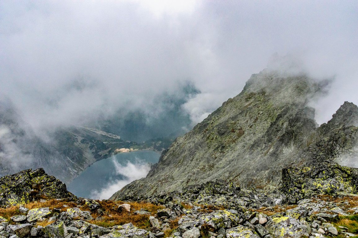
20. Rysy, Poland
Length: 23km / 14.5mi
Time of hike (breaks included): 12 hours
Difficulty: high
Rysy mountain reaches 2499 metres and it's the tallest peak in Poland. It's actually a mountain massif which consists of three peaks, two of which belong to Slovakia.
By the way, did you know that Slovakia is one of the most mountainous countries in Europe?
The trail leading to Rysy is located in High Tatras in southern Poland. Tatra mountains are considered by many hikers as one of the most beautiful mountains in Europe! The dramatic landscape of granite summits and pristine nature attracts all kinds of nature lovers.
Another perk of Rysy hike is the fact that we pass several beautiful glacial lakes - it's a real eye candy and a perfect place to take a break and soak in the mountain nature.
The best option to complete this hike is to start in Zakopane (Morskie Oko parking, Palenica Bialczanska).
The first part of the trail leads on an asphalt road. After about 2 hours we get to Morskie Oko mountain hut and admire the first amazing lake. We continue our hike on a red trail which gets steeper the further we hike. After about 2 hours we get to another scenic mountain lake.
Then, the trail gets really steep and the fun begins. We get to admire the spectacular landscape of high mountains, raw but so beautiful! After 2 hours we see the first chains where a bit of climbing skill comes in handy.
The best way to climb down is to continue on the red trail in Slovakia towards Štrbské Pleso.
Rysy hike is rather demanding and not suitable for beginners:
- significant height difference to hike
- lots of exposure points (not suitable for hikers with the fear of heights)
- chains in the upper part of the trail
Rysy hike is very popular among Poles and international mountain lovers. Many hikers consider it one of the best hikes in Europe! As every country's highest mountain it attracts lots of hikers, especially in the summertime. To avoid waiting in the traffic jam near Rysy mountain top it's best to hike on a weekday, ideally in September where there's no snow on the trail and fewer hikers.
If you want to try hiking in Europe and experience some exciting outdoor adventures, then Tatra mountains are just for you!
For more detailed description check below articles:


