
Balkan peninsula is well-known for beautiful coastline, sandy beaches and picturesque towns full of monuments and castles. It is also one of the most beautiful cheap places to travel in the world.
But did you know that the Balkans offer some of the best hikes in Europe?
In the Balkan Peninsula there are many spectacular mountain ranges, which are still not that popular among tourists. They take your breath away with beauty and nature's wilderness. Whoever visits Balkan mountains, irrevocably falls in love with them.
However, there is a very important thing to remember about before hiking in the Balkan mountains. It is safety - we need to come prepared:
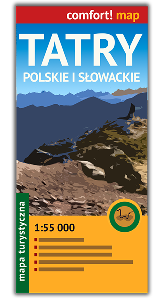
- choose proper map
- stay safe during winter hikes
- choose well your backpack
- take all necessary hiking gear
- avoid these common mistakes in the mountains
So, let's have a look at the best hikes in Balkan mountains. Those are Balkan trails reviews, all prepared by fellow bloggers, who hiked those paths and loved them!
Table of contents
1. Plitvice Lakes National Park in Croatia
Endorsed by Constance from theadventuresofpandabear.com
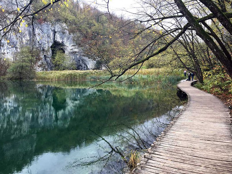
Plitvice Lakes National Park has some of the most beautiful trails in Croatia. It is the oldest national park in Croatia and also one of the most famous. It is known for its beautifully colored lakes and gorgeous waterfalls with wooden plank pathways. There are several trails that are great for exploring the park and recommendations vary depending on the amount of time you have available.
The park has signs throughout telling you the various alphabetically-named trail routes which begin at specific entrances. Trails A, B, C, and K begin at the Entrance 1 (North) and paths E, F, and H begin at Entrance 2 (South). Some of these trails overlap and may include a boat or bus ride.
Under the guidance of a park ranger, we decided to take the C trail which takes approximately 4 to 6 hours and is 8 kilometers or about 5 miles long. He had recommended this route because we would be able to see most of the park, including the Upper and Lower Lakes.
This trail also allowed us to take the boat across Kozjak Lake as a break in the middle of the hike and on the way back take the bus back to Entrance 1 (North) as the final leg of the hike.
We also loved taking in all the beautiful sights while walking along the wooden plank and gravel pathways. The lakes are gorgeous with rapidly flowing waterfalls, and there is even a cave you can climb up to along the trail!
Trail C was amazing because it didn’t take all day, though it did take most of the day, but also we found that sitting on the boat and the bus was sufficient rest for us while hiking throughout the park. It was a great way to explore Plitvice Lakes National Park all in one day.
You may find available accommodation near this beautiful area here:
2. Dragon Lake of Tymfi in Greece
Recommended by Helena from justforonesummer.com
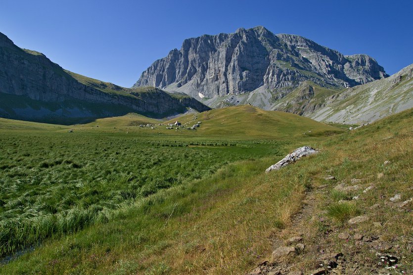
Hiking to the Dragon Lake of Tymfi from Konitsa is one of the best ways to experience the striking landscape of the Zagori region in Northern Greece. From old stone bridges and charming monasteries to mountain lakes and rugged peaks, there is plenty to see along the way.
It is not an easy hike, though. It takes around 9 hours of a steady climb to reach the lake requiring a good level of fitness and a lot of stamina. However, the trail is clearly marked and easy to follow and there is no need to carry a lot of equipment thanks to the perfectly placed Astraka Refuge near the lake.
The trail starts from the stone bridge of Konica, the tallest one in Zagori, and follows the Aoos River for about 5 km to Stomio monastery. This is the easiest part of the hike with little elevation and beautiful views of the lush green valley and unusually shaped peaks of Mount Tymfi.
From the monastery, the terrain changes dramatically. The path climbs straight up the steep rocky slopes of the mountain for 3 to 4 hours and is a true challenge. However, once you reach the plateau of Mount Tymfi all your suffering will be rewarded by stunning views of the surrounding peaks.
The lake itself lies at an altitude of 2050 meters and is one of the highest placed mountain lakes in Greece. Legend has it, it was created by two cranky dragons living in the are constantly throwing rocks at each other. True or not, it is a magical place and absolutely worth the long climb.
Once you get enough of the Dragon Lake or Drakolimni, as it is called in Greek, head to the opposite side of the plateau to the Astraka Refuge for the night. The refuge sits at an amazing location at the foot of Astraka peak and except of simple accommodation and tasty meals offers one of the most stunning sunsets I've ever seen!
Below you can check available hotels near Vikos-Aoos National Park:
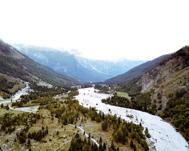
Albania is a country that has a lot of things to offer. One of Albania's most scenic trails is the hike from Valbona to Theth in the Albanian Alps.
This trail belongs to one of the most spectacular places in Albania - Valbona Valley National Park.
The path of Valbona to Theth starts in Valbona from the last hotel at the end of the asphalt road. You will make your first meters through a small area with pine trees before you follow the river bed for 3,5 km. You have to follow the red-white-red markings. After the river section, you will see some houses in the distance that belong to the village of Rragami. While this is a small village and should be easy to navigate, this is not completely the case. There are some small paths that will lead you to private properties. So, if you're not sure, just ask some locals.
The first part of the trail is not difficult, but after you pass the Rragami village it gets more challenging - you start the ascend. From Rragami you will need to climb to the Valbona pass which is 1.759 meters high. Before you reach the Valbona pass, you will pass Valbona spring. Here you will find a small café to rest.
After about 4-5 hours most people reach the pass from Valbona. The view from this pass is stunning, so take your time before your descent.
After that, you have to descent around 1000 meters to get to Theth. Before you reach Theth you will pass the village of Gjelaj and Theth can be seen in the distance. As you walk into the direction of the river it will lead you to Theth.
Length of the trail: 9,5 km
Time of hike: it depends on how fit you are. The hike from Valbona to Theth can be done by anyone who is reasonably fit. The whole hike should take 6-7 hours, but it depends on the number of photo stops and rests that you take.
Here you may find available accommodation close to this amazing area:
4. Mount Vodno in Macedonia
Proposed by Alice from teacaketravels.com
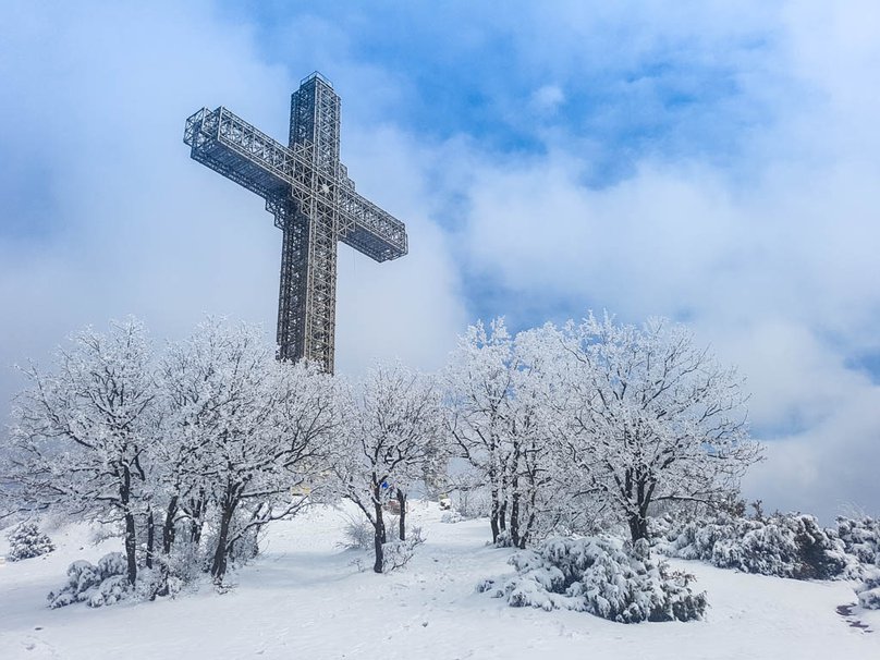
Hiking from the city centre of Skopje up to Mount Vodno in Macedonia is a lovely, easy hike that can be done by all ages – and the views at the top are well worth the effort!
The highest point of Vodno mountain reaches 1066 metres. On the top there is a famous 66-metre high Millennium Cross.
The trail begins at the bottom of the mountain just off Todor Aleksandrov road. From here, start walking up the road that twists and turns up the mountain. There’s plenty of space for cars and pedestrians, so do not worry too much about having enough space! If for some reason you do not feel you will be able to make it all the way to the top, there is a cable car which makes its way up Mount Vodno. You can catch a ride at Sredno Vodno if need be for just 100 MKD return.
If you’re determined to make it all the way up on foot, keep following the clearly marked path away from any cars this time. The total amount of time to get up to the top should take around 2 hours.
Once you’re at the top, your options from here are varied! You can stay in this area and enjoy the vast views of Skopje city from beneath the Millennium Cross, or you can continue your hike here all the way to Matka Canyon, 15km away!
Below you may check available hotels in the capital of Macedonia:
7 Ladders Canyon and Piatra Mare combine to make a gorgeous day hike for any outdoor enthusiast visiting the town of Brasov, Romania.
7 Ladders Canyon can be done by itself for a shorter day hike. There’s a small entrance fee for day use. The trail follows a canyon that has been carved out by the stream below. There’s a system of platforms and ladders that lead you through the forest and past waterfalls. The scariest part for me was a 10 meter (32 feet) ladder that was wet and cold from the cascading waterfall beside it.
Upon completing the 7 Ladders Canyon hike, you can choose to keep hiking through the forest and up the mountain. It’s a steep climb upwards, and it takes quite a while to finally break through the tree line. However, once out of the trees, it’s a pleasant hike through meadows with views of the surrounding Carpathian Mountains.
Access this hike from Brasov by taking the 17B bus from the train station to the village of Dambu Morii. Then walk through the village to the trail head.
Distance: 15 km/ 9.3 miles
Length of time: 6 hours with breaks
Here you will find available accommodation close to 7 Ladders Canyon:
6. Bobotov Kuk in Montenegro
Favorite hike of Allison from eternalarrival.com
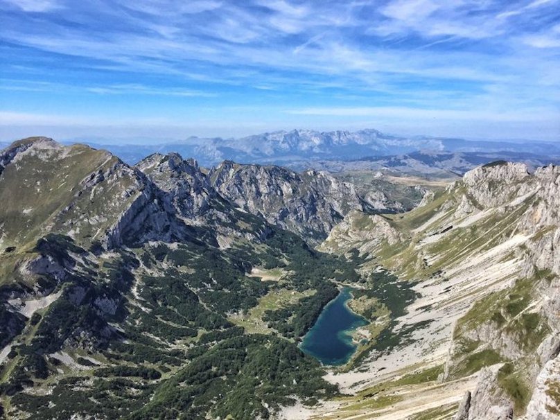
One of the most beautiful trails in the Balkans is the Sedlo Trail in Durmitor National Park, Montenegro. This trail starts in the small village of Sedlo and leads to the peak of Bobotov Kuk, the highest mount in Durmitor.
From the top of Bobotov Kuk, you can see three different countries: Serbia, Bosnia & Herzegovina, and Montenegro.
The trail starts off quite difficult with a steep ascent up, but then levels out to a more moderate and level hike for several kilometers. However, once you reach the first glacial lake, it’s a long and difficult slog up the mountains. The rocks at the base of the mountain are quite loose, making it very easy to lose your footing if you’re not careful!
The hike up to Bobotuv Kuk is quite steep in addition to being on loose rock, so it is best done slowly and methodically. It took me about 3.5 hours to ascend from the starting point at the base of the Sedlo trail, and another 3 to go back down. The trail is 10 kilometers round trip and you hike to an altitude of 2,523 meters, so it is easily doable in a day without any special gear, even if you are a relatively inexperienced hiker.
I did this hike in September and the weather was perfect; however, I did the hike a few days after some rain so it was quite muddy and I slipped along the path a few times. If it’s recently rained, be extremely careful as the rocky part at the summit in particular can be quite treacherous! I don’t recommend doing this hike outside of the typical June-September season as snow and bad weather could make this hike quite dangerous if inexperienced in winter hiking.
Here you may look for available hotels close to Durmitor National Park:
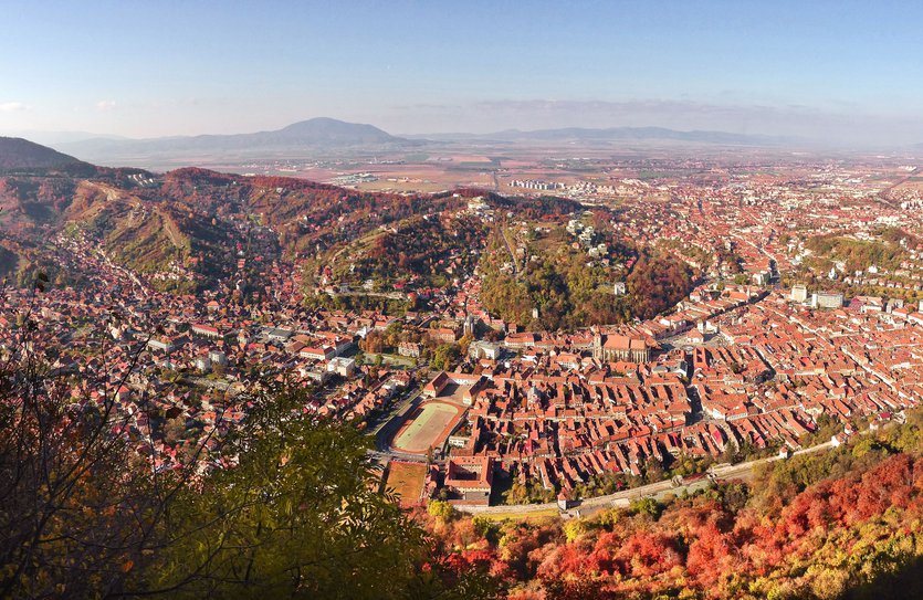
Located in Transylvania, Brasov is a very beautiful historical city and one of the most visited in Romania.
One of the main tourist attractions here is Tampa Mountain, on top of which you can see the huge letters that make up the name of the city. Mount Tampa is about 950 meters high and is located right in the heart of Brasov, offering a gorgeous panorama of the city.
You can reach its peak either with the cable car or hiking on one of the trails, marked with colourful signs. Routes have different degrees of difficulty suitable for each type of hiker, both experienced or beginner. Each trail takes about an hour to get to the top.
The four hiking trails are called Serpentine Road, Knights' Road, Forest Road, and Gabony's Steps (in Romanian Drumul Serpentinelor, Drumul Cavalerilor, Drumul forestier si treptele lui Gabony). The last one is the most exhausting, but it offers incredible views, a great reward for the effort.
At the top, there are several view points from where you get to admire the old center of Brasov and the impressive Black Church situated in the center, but also a beautiful panorama of the Schei neighborhood. Beware, you need to be careful because there are chances you encounter wild animals such as bears, vipers or wild boars.
Here you will find available accommodation near Tampa mountain:
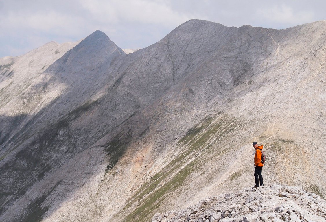
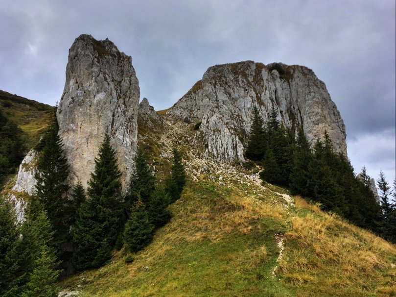
8. Koncheto Ridge in Bulgaria
Recommended by Jack and Jill from jackandjilltravel.com
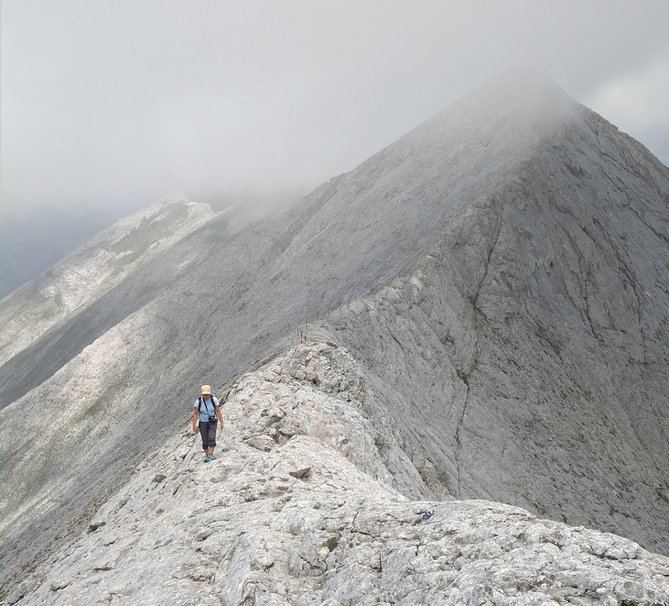
Hiking Mt. Vihren and Koncheto Ridge in Pirin National Park was one of the highlights of our visit to Bulgaria and also one of the best hikes in the Balkans.
Vihren reaches 2914 metres and is one of the most spectacular mounts in Balkan peninsula.
Koncheto means “Little Horse” in Bulgaria and the name came from the fact that there’s part of the ridge so narrow and exposed that you might have to get down on your butt and scoot, it was that narrow. (This was what I did). The spectacular scenery, the length (doable as a day hike from Bansko mountain resort) and the adrenaline rush that comes with the exposure makes it one of the must-do hikes in the Balkans.
From the small town of Bansko, you can do this hike in one long day. You take a shuttle bus from Bansko to Vihren Hut (food, drinks, and lodging is available here) and follow the trail system to Koncheto Ridge. Then it is all about traversing the ridge while summiting 3 peaks: Mt. Vihren, Kutelo I, and Kutelo II.
Note: it’s also possible to do the hike the other way around, by first summiting Mt. Vihren.
The total round trip hike from Vihren Hut takes about 8-9 hours. Caution: the trail might get busy in the summer. The part where it’s narrowest on the ridge can get dangerous when the trail is wet. So keep an eye out for the quick-changing weather and wear appropriate layers.
Here you can check available hotels near Pirin mountains:
9. Kotor City Walls in Montenegro
Proposed by Jeanne from learningtobreatheabroad.com
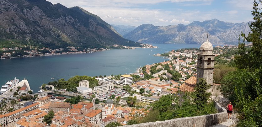
The hike up the Kotor City Walls is one of the top things to do in Kotor in Montenegro. The huge fortified city walls extend high up into the mountains behind the old town of Kotor and those persevering right to the top will be afforded the most incredible views over the Bay of Kotor.
All that stands between you and St Johns Fortress at the top are 1350 stairs and an ascent of 260m. It is not called the “Huff and Puff Trail” for nothing!
The trail can be started from the South or North City Gates and there is a small fee of €4 per person.
The trail climbs quite quickly and within 20minutes you should reach the Church of Our Lady of Remedy. The view from here is already wonderful, but don't stop just yet! The next landmark is the ruins of a military building with crumbling walls. Shortly thereafter you'll see a hole in a wall. If you're looking to extend your hike then climb through the hole to visit St George’s church nestled in the little valley and if you want to return to Kotor via the Ladder of Kotor, then this is the route to take. For now, keep climbing up till you reach St John's Fortress, then find a place to sit and just soak up the breathtaking views. You'll have earnt it!
If you go straight up and down it should take about 2 hours. If you go up the city walls and down the Ladder of Kotor it could take up to 4 hours.
Below you can look for available hotels in Kotor county:


